Feasibility of the use of the LandPKS technological applications for the evaluation of soils in situ by livestock raisers and farmers of the municipality of La Plata
“VIABILIDAD DEL USO DE LA APLICACIÓN TECNOLÓGICA LANDPKS PARA LA EVALUACIÓN DE SUELOS IN SITU POR PARTE DE GANADEROS Y AGRICULTORES DEL MUNICIPIO DE LA PLATA.”
by Daniel Rodríguez Acosta, Octavio Clavijo Cabrera, and Deyanira Lobo Lujan
Published: 30 November 2023
(Note: This study was conducted with the legacy LandPKS mobile application)
Abstract:
The soils in the municipality of La Plata show high susceptibility to degradation processes, especially water erosion, due to the magnitude of rainfall, the relief of the area and the production systems. Highlighting that the majority of farmers have strengths in the activities of their work, but a great weakness in the base that allows the success of their products (soil management). Due to this situation, the validation of the use of the LandPKS technological application for the evaluation of soils in situ by ranchers and farmers in the municipality of La Plata was carried out. For this, the methodology consisted of carrying out joint work between the technician, producers and the LandPKS application, which is operated from a cell phone. The protocol was carried out on a sample of 200 livestock and agricultural farms, which were located according to the registry of livestock farmers provided by the ASOGANPLAT association and the information provided by the SER program of the Agrobusiness and Tourism Development Center of Huila (SENA). in such a way that before going to the field, contact was made with each of the owners to agree on an appointment, next step they proceeded to visit each property, socialize the methodology that was going to be implemented, and then together with the owner, if possible, an exploration of the soil was carried out, using a pit, and the data was recorded for its respective interpretation, where the owner of the property was the protagonist of the characterization of his soil, then an interview was carried out to determine the producer’s perception of the process carried out. Once the field activity was completed, the panel of expert researchers proceeded to carry out an analysis of the appropriation of knowledge, as well as the strengths and possible continuous improvement that could be made to the LandPKS methodology and application, to strengthen the knowledge of the peasants, in terms of understanding the soil through a simple and easily interpreted language. The results showed that, although in principle the application is a tool for managing technicians, 99% of the peasant participants felt comfortable being able to interact with a technological tool that provided them with information in real time. The 46% of the producers presented the type of cell phone as a limitation; it is notable that participation was 70% by women. The variable that provided the least confidence was the color of the soil, because the results change from one cell phone to another. In general, each of the shortcomings found in the process were corrected and the respective recommendations were generated to obtain the greatest benefit from the application and the appropriation of the producer’s knowledge.
The content below is translated to English from the original Spanish.
Methodology
Location
The study was conducted on 200 livestock and agricultural farms in the municipality of La Plata. Figure 1 shows the paths that were intervened and the sampling points on each farm.
Phase 1. Technological surveillance
It was carried out through consultations in scientific databases and official technology websites; Likewise, a literature review was carried out by each of the members of the research project, with the purpose of having a greater command of the use of mobile applications for the field, as well as strategies for working with rural communities, which were key to carrying out extension work with farmers and ranchers.
Phase 2. Training of the field team
During a period of 30 days in the office and field, specific training was carried out related to soil diagnosis and management of the LandPKS application, in order that the researchers who would carry out the field recognitions could know and identify the state of soil quality, coverage, changes in land use, climate and the availability of management alternatives offered by free-access mobile phone technologies. This is how field practices were carried out during this time, with the diagnosis of the test pits using the LandPKS application, then the results and doubts were socialized in the laboratory, which were addressed by reinforcing the group’s knowledge, and procedural or interpretation errors were eliminated, until standardizing the study protocol. The materials and tools were selected according to their ease of acquisition and availability to the community in general.
Phase 3. Participatory Management
Two major meetings were held. The first was conducted with the livestock association of La Plata and western Huila, Asoganplat, where the objectives of the research were presented. The aim was to inform producers about the topics to be developed in the research project and to encourage the participation of livestock farmers. The second meeting was held with the SER program of the Agrobusiness and Tourism Development Center of Huila (CDATH), where the purpose of the study and its processes were shared with all the instructors who provide training to rural agricultural communities (as they are the ones with presence and acceptance in the field). These instructors actively participated in the meeting and facilitated spaces for specific meetings and direct interviews with property owners.
Phase 4. Location of properties and personalized meetings
With the support of the livestock association and the collaboration of the SER program, 200 farms were located for the development of this study. Specific approaches were made in person and by phone, depending on the availability of each property owner, to determine the best time for the study and ensure their presence to assist the field team (junior researcher and field assistant). Once the date was agreed upon, the research team went to the field, using tools and instruments similar to those available to farmers or ranchers on their property and that were easy to acquire, ensuring that they could replicate the processes after the study.
Phase 5. Soil diagnosis
At each selected site, together with the property owner or manager, a hole was dug to a depth of 120 cm using basic tools such as a bar, shovel, and auger. The LandPKS analysis protocol was then implemented, analyzing variables from the surface to the bottom of the pit, such as depth, soil texture class, volume of rock fragments, slope, biological activity, pH, aggregate stability, and other observations of factors that could limit the soil. The evaluation using the mobile technology protocol was designed to be quick, flexible, and clear. The researcher explained each step to the property owner or manager, promoting active community participation.
The knowledge appropriation was then evaluated using two research instruments: interviews and surveys. These analyzed the observations from the interaction with each producer regarding the use of the application, highlighting the advantages and areas for continuous improvement to refine the methodology.
Phase 6. Information recording
The information collected in the field was recorded in an Excel database, considering the application variables, observations, and field data. Every eight days, field team members met to share their experiences from the properties where the soil diagnosis and interpretation process was conducted. Relevant observations for the study and community were documented in meeting minutes.
Phase 7. Field verification
Taking into account the evaluations carried out in the previous phase, the soil professionals of the CDATH made observations on the process carried out by each of the crews together with the producers, data were taken in the field, as well as particular samples of the calicata to validate the information in the laboratory of the recorded soil variables.
Phase 8. Information analysis
The information was analyzed by a panel of soil experts, in such a way that the quality of the information and the most reliable soil variables were evaluated; likewise, the experience of each of the technical participants, and of the agricultural and livestock producers regarding the use of the methodology using the LandPKS application was assessed. The panel of soil experts proceeded to generate contributions regarding each of the variables of the application, taking into account what the producer, the technician and the soil professional considered most relevant and gave it the highest degree of importance, in such a way that continuous improvement adjustments could be generated, and the general community could have in a more practical way data, interpretations, viable and understandable protocols in the analysis of soils for the management of their properties.
Results
Producers’ impression of the Mobile application
After the project was socialized and the soil diagnosis was carried out with the LandPKS mobile application for each of the producers, they were asked for their point of view regarding how they would rate the experience on the soil evaluation with the application and the techniques carried out in the field, for which 99% of the participating community stated that they were very satisfied with the new experience and that this type of technology existed, since the appreciation was excellent to good, only 1% rated it as regular (Figure 2), because they considered the use of the cell phone complex and did not have relatives who could help them with the process, so they depended on the technician all the time.
People stated that they highlighted that the process was so practical, with direct results, and they did not have to wait. Some expressed dissatisfaction with extensionists who took samples to analyze the soils in the laboratory and that in the end they only ended up recommending a series of inputs, which were the same ones they have been applying conventionally. They also highlighted being able to be part of the process and interact with the soil diagnostic tools.

Figure 2. Producer’s rating of the soil diagnosis experience through a mobile application
94% Excellent
5% Good
1% Regular
0% Bad
Limitations for knowledge appropriation by producers
Although the participating community enjoyed being part of the on-site soil diagnosis, three limitations were encountered that prevented them from fully mastering the application at the time of their soil diagnosis: i) the type of cell phone that did not support fourth-generation mobile processes; ii) the Internet, despite the application being usable without internet after downloading. Therefore, these two variables can be combined since they have a direct relationship with the cell phone equipment, representing a joint limitation of 68%, since if there is mobile equipment, data for internet access can be acquired; iii) the availability of time to participate in the practical soil diagnosis processes and application management with 12% of the participants. This last was mainly due to livestock producers since they do not reside on the properties and have managers in charge of their production processes, while farmers were more participatory in each of the processes. 20% of the producers considered that they did not have any limitation to appropriate the knowledge of soil diagnosis using the application (Figure 3).
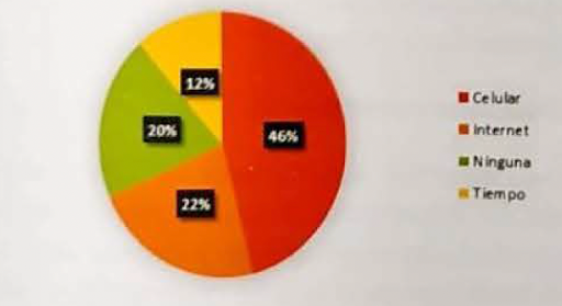
Figure 3. Limitations to knowledge appropriation in mobile application management
Gender Participation in the Study
The gender that participated the most in the soil assessments was female, accounting for 70% of the total (Figure 4), while men accounted for only 30%. This was largely due to the fact that agricultural farms practice family labor, where roles are divided.
The head of the household is primarily responsible for production and farm maintenance, while the wife or children are responsible for other farm tasks, such as participating in this study and then informing the family about the experience.
On some of the livestock farms, it was found that the farm owners delegated the task to a steward, where again, women took precedence as participants or together with their husbands.

Figure 4. Percentage of gender participation in soil assessments
Percentage of participation of agricultural and livestock owners in soil analysis and application management
The people who were most interested in soil diagnosis using the application were agricultural owners, with 98 % of participation, since the other 2% for a time no member of the family could participate. On livestock farms, the involvement of the owners was 41%, since the other 59% stated various reasons for not being present, such as not living on the farm or having other activities to perform, generally delegating a steward to participate in the study.


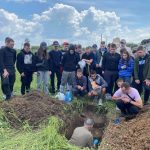
Figure 5. Ranchers (A) and farmers (B) participating in soil assessment using the mobile app.
Automatic translation of the application
Errors can occur when interpreting the information provided by the LandPKS mobile application if the application’s automatic translation into Spanish is used as a guide, since the application’s original language is English. Therefore, when Spanish is selected, the translator generates texts that cause the user to associate terms from their language that do not correspond to what the application actually intends to direct them to. This does not happen when the application is used in its original language. To remedy this situation, the field team provided comprehensive support to the producer and provided him with a guide document so he could replicate the process. Furthermore, although the same language is spoken in Latin America, some words can have different meanings, which complicates interpretation.
Variables
One of the contributions to the continuous improvement of the LandPKS mobile app would be to include variables tailored to Latin America, since there are terms that are not applicable and could be misinterpreted by users when choosing an option, leading to errors throughout the entire procedure without even realizing it. For example, in the case of soil preparation instruments, none were adapted to the jargon used by producers or crew members, so it is suggested that the options be expanded.
Global Positioning
It was determined that data collection from the test pit should not be done near the boundaries of a property, because accuracy varies from one cell phone to another, and therefore the geographic location could be skewed, generating erroneous coordinates corresponding to a neighboring property or a different place is not likely. A position error verification system would be desirable.
Color
The image record generated many concerns because, when performing tests on different types of soil to determine the color, variability was found from one cell phone to another, and this inconsistency was caused by different factors, such as the weather, which influenced the available light, the angle of inclination, and others related to the image capture. Therefore, for this study, color was not a reliable factor, even though much of the soil’s behavior can be determined from it, and it is also an important characteristic for the taxonomic classification of soils. Therefore, in order not to rule out this powerful variable, laboratory tests were conducted using data obtained from the application and the Munsell table. It was found that cell phones can generate colors that do not match the table, that accuracy can change depending on the user’s cell phone, and that the distance and angle of Image registration also influences the soil color algorithm. This is why this study led to the development of a new research process for the construction of a simple tool that allows photographs to be taken at a specific angle, distance, and light with specific equipment that most closely approximates the data in a Munsell table.
Recommended Digital Equipment
Ultimately, high-end cell phones allow for better use of the app; however, the number of producers who have this type of technology is very limited. This study showed that the use of conventional fourth-generation cell phones brings producers and technicians closer to a practical understanding of the soil, since the app, by providing step-by-step instructions, allows for the application of knowledge in the field, which is strengthened with practice, without requiring total dependence on technology.
Recommended Mechanical Equipment
In the procedure for assessing soil in situ using the LandPKS application, the greatest physical effort is digging the hole, which is done with basic field tools such as a trowel, a bar, and an auger, depending on the soil condition. Therefore, in this study, it was established that a tool that can significantly save time in diagnosing multiple points on the same property for applying precision agriculture or simply obtaining more detailed information about the property’s soils is an earth auger with an auger bit. This tool greatly reduces physical wear and tear, and its use would be limited by the proportion of rock fragments found in the soil volume of the property.
Soil Biological Activity
The LandPKS application collects the percentage of organic matter as input data; however, this variable is not easy for producers to perform on-site to obtain real-time data. To overcome this limitation, the NOVA research team developed and tested a simple protocol that could be used by producers to evaluate soil biological activity along the verticality of the pit. This protocol was applied along a line from the surface of 0.2 cm3/cm3 of 30% hydrogen peroxide, with a reaction time of one minute. During this time, the depth to which effervescence was achieved was measured, as well as the area of greatest effervescence. The process was enthusiastically adopted by the farmers, as It turns out to be very economical and gives a visual idea of the biological enrichment of the soil, making it easier to determine which areas of the property should be enriched with organic matter and efficient microorganisms that promote soil sustainability.
Determining the texture to the touch
In the application, the protocol is not sufficiently clear regarding the explanation of moistening the soil (without oversaturating it) before making the ball and tape. Therefore, the field crew corrected this part by explaining to the producer that the goal was to ensure that the soil sample in his hand did not ooze water and that when he touched it, he remembered how Play-Doh feels.
Aggregate Stability
The application protocol allows soil technicians to determine aggregate stability. However, to enable producers to assimilate the information, they were explained that the 5 mm aggregate size was pieces that, when held between the thumb and index finger, were approximately half a centimeter high. The sample size in the sieve, to be soaked in water for one minute, was 4 tablespoons of soil.
Presence of Mottling
The application does not include the presence of spots or mottling, which would be a soil attribute closely related to limitations caused by water movement or the presence of fluctuating groundwater levels. Therefore, it would be advisable to include this factor.
Taxonomic Classification of Soils
Taking into account that when the variable soil color is measured in the application, the result depends largely on the type of soil cell phone that is used for sanding, as the results vary when measured from one cell phone to another. Therefore, in this situation, it is recommended to directly use the Munsell table in the field. This will allow for optimal information processing from the LandPKS application.
Ease of use for the farming household in the application management
The children of the landowners and young people in general find it much easier to adapt to the application management because they interact more with the cell phone. This facilitated the implementation of soil diagnostic processes in the field, but with a high degree of dependency. This would be advisable as long as the next generation continued to develop the processes in the field, since managing this type of tool would facilitate the evaluation of both the productivity and sustainability of the soil. But the other scenario is that many of these young people focus on the city, which is why the appropriation of knowledge decreases due to the lack of practical and constant monitoring of the process. For this reason, there is a need to develop a practical guide focused directly on older farmers that is aligned with current technology, so that both generations can promote, through diagnosis, practices for the sustainability of their properties in their distinct dependencies.
Land PKS Documents
There are limitations in the field for downloading soil assessment documents, associated with internet availability, which is why this process can become a complex situation. To mitigate this impact, the crews conducted the assessments with the producer on-site without depending on the written result, which encouraged the producer to learn by doing it in the moment.
Conclusions
The use of the LandPKS technological application for in situ soil assessment by ranchers and farmers in the municipality of Plata proved to be a high-speed alternative. Although some limitations arose in the management of some variables and the application, these were included in the present study, thereby ensuring the relevance of the specific recommendations. The impact of this research was positive, as it provided a significant contribution to the project regarding soil diagnosis.
It is of greater relevance to farmers and ranchers, as the latter largely do not reside on the land and are entrusted with their production processes by a manager.
The use of the mobile tool provided relevant methods for assessing soil potential by integrating open and free tools, seeking to strengthen information for decision-making regarding the rehabilitation of lands in the municipality of La Plata for agricultural and livestock production.
The application of its application as a scientific assessment instrument allows a soil expert to make in-situ decisions; however, this study showed that the tool can also be adapted for use by agricultural and livestock producers, provided that initial support is provided and the community is provided with easy-to-interpret educational materials.
Measuring soil color using the LandPKS app depends largely on the phone used, as the effectiveness of the measurement can vary from one phone to another.