LandPKS Soil ID relies upon soil maps to make a soil prediction. You can learn more about how LandPKS interprets soil maps here. The soil map used by LandPKS will depend on the location of your site.
United States soil maps
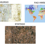
For sites inside the United States and its territories, LandPKS uses two soil maps created by the National Resource Conservation service: SSURGO, and STATSGO.
SSURGO
For sites in the United States and its territories, LandPKS uses the Soil Survey Geographic Database (SSURGO) map, where possible.
The data used to generate the SSURGO soil map was gathered by walking over the land and observing the soil. Many soil samples were analyzed in laboratories. SSURGO data is mapped at about 30m resolution.
STASGO
Where SSURGO data is not published in the United States, LandPKS uses the Digital General Soil Map of the United States (STATSGO2). STATSGO data may be used in locations such as military bases, tribal territories not participating in the SSURGO process, or areas where SSURUGO data has been gathered but not yet digitized.
STATSGO was built by generalizing other soil maps. Where soil maps were not available, data on geology, topography, vegetation, and climate were assembled and related to Land Remote Sensing Satellite (LANDSAT) images. Soils of similar areas were studied, and the probable classification and extent of the soils were determined. STATSGO data resolution varies and can reach 300m resolution.
Due to their resolution and the process by which they are made, STATSGO maps are less likely than SSURGO maps to provide the correct soil.
Global soil maps
HWSD
LandPKS uses Harmonized World Soil Database (HWSD 2.0) soil maps for all sites outside of the United States and U.S. territories. HWSD is the result of harmonizing many soil maps, the quality of which may vary from location to location. HWSD has global coverage, and is mapped at 1000m resolution.