Knowing what soil is present in your land is critical to making sustainable land use decisions. Your soil type, climate, and topography, combine to make up your land’s potential. This information can help you to understand what crops might grow there, and how much livestock it can maintain.
On the other hand, not knowing your soil type, or obtaining an inaccurate Soil ID, can lead to inappropriate management actions, land degradation, and wasted money. Without the proper knowledge, you could end up amending your soil improperly, planting a crop that won’t prosper, or trying to support too much livestock.
LandPKS streamlines and simplifies the process of soil identification, so you have a solid foundation on which to make land management decisions.
I have a soil map — why use LandPKS Soil ID?
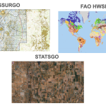
A common way to identify soils is to look up a location in a soil map. Soil maps are useful because they cover a broad range of territory: some cover an entire continent, or even the globe, meaning that if you know the coordinates of a location, you can probably look it up in a soil map and obtain a prediction for what soils are present.
Soil maps come with downsides, however. LandPKS has been designed to complement soil maps to obtain the best result.
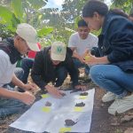
Standard soil maps often list a few possible soils for each location. This can be hard to interpret if you aren’t an expert in soils. A common mistake for non-experts is to assume the most prevalent soil in an area (according to a soil map) is the correct one. LandPKS allows you to collect and organize observations, and compare with nearby soil profiles, removing this element of guesswork.
Soil maps also are inherently low resolution. They are predictions which, at scale, can often be inaccurate. Soil ID improves upon soil map predictions by ranking them through user-collected observations. In the U.S., once supplied with ground-truthed data, LandPKS suggests the correct soil 94% of the time.
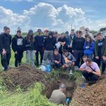
Here is an example of how LandPKS Soil ID builds upon soil maps to make soil identification easier. A soil map might suggest two possible soil types for a location. One may have high clay content, the other is more sandy. Using LandPKS, you can dig a soil pit and determine the soil texture class for a certain depth. This alone may be enough to help you determine that the soil is in fact the sandy soil. LandPKS will help you in this process by interpreting the observations you’ve gathered, and ranking the possible soils to help you understand which one is most similar to the observations you’ve entered.
For more information, read about how the Soil ID algorithm works.
Making decisions based on Soil ID
Once you have determined the Soil ID of your soil, you can start making management decisions. With data about your soil in hand you can:
Seek expert advice: Soil scientists, agronomists, and other land use experts can interpret Soil ID information and make recommendations for how to sustainably manage your land. To share your data with a third party, either add them to a project that contains sites or download the data and send it to them.
- Look up management practices based on your soil: LandPKS provides a description of each of the potential soils at a site. If the site is in the United States, it will link to a full soil description provided by the Natural Resources Conservation Service. This soil description includes management information under “Use and Vegetation”.
- Review recommendations provided by LandPKS: Part of the mission of LandPKS to make recommendations for sustainable land use. If your site is outside of the U.S., the Soil Info sheet will provide management guidance. Over time, we will add more tools to help people make informed decisions about their land.
Soil properties
Many observations you can make with LandPKS can lead to valuable insight about the land, independent of their use in identifying soil type. For example, LandPKS guides you through the process of determining texture class: the proportional makeup of your soil in terms of clay, silt, and sand. Knowing the texture class can help you anticipate drainage, porosity, and nutrients, and can help you decide what plants to grow in your soils. Seek expert advice for how to interpret your soil data.